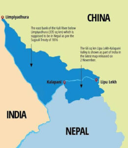
In news- Nepalese political parties expressed a general consensus over the fact that Kalapani in India’s Uttarakhand is part of Nepal’s sovereign territory.
About Kalapani-
- Kalapani is a 372-sq km area at the China-Nepal-India tri-junction and since 1962, has been manned by the Indo-Tibetan Border Police (ITBP).
- India claims Kalapani as a part of Uttarakhand while Nepal depicts the area in its map.
- In 1816, the East India Company and Nepal signed the Treaty of Sagauli under the conclusion of the Anglo-Nepalese War and Nepalese territories including Darjeeling were handed over to the British East India Company as concessions.
- India claims that the river Mahakali begins in Kalapani as this is where all its tributaries merge.
- But Nepal claims that the river begins from Lipulekh Pass, the origin of most of its tributaries.

- Hence Nepal has laid claim to all areas east of the Lipu Gad – the rivulet that joins the river Kali on its border.
- According to some sources, the late Nepalese King Mahendra had “handed over the territory” to India in 1962 in the wake of the India-China war.
- Nepal has claimed that India had occupied an additional 62 sq km land.
- However a map of 1879 shows Kalapani as part of British India and India on its part has presented administrative and tax records dating back to the 1830s to back its claims.
- Nepal has also raised concern over Lipulekh Pass, which has been made a trading tri-junction route between India and China, reportedly without Nepal’s consent, since 2015.
- However the Indian side claims that Lipulekh pass has been referred to as a border trading point since 1954.
- Since the Indian government released the new map of India on November 2, 2019, following the reorganization of Jammu and Kashmir, Nepal has claimed that the Limpiyadhura, Lipulekh and Kalapani areas shown in India’s maps lie within its territory.
- Nepal’s Supreme court ordered the government to submit the original map exchanged with India during the signing of the Sugauli treaty in 1816.
- However India has rejected allegations and has said that the map accurately depicts the sovereign territory of India and has in no manner revised its boundary with Nepal.


