In news– As Super typhoon Hinnamnor and another tropical storm called Gardo approached each other, they started a dance around the central line between them, showcasing a textbook example of what is known as the Fujiwhara Effect.
What is the Fujiwhara Effect?
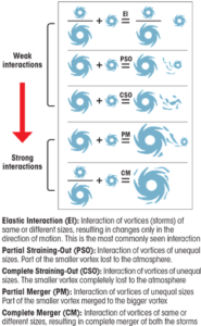
- Fujiwhara Effect is any interaction between tropical storms formed around the same time in the same ocean region with their centres or eyes at a distance of less than 1,400 km, with intensity that could vary between a depression (wind speed under 63 km per hour) and a super typhoon (wind speed over 209 km per hour).
- The interaction could lead to changes in the track and intensity of either or both storms systems.
- In rare cases, the two systems could merge, especially when they are of similar size and intensity, to form a bigger storm.
- There are five different ways in which Fujiwhara Effect can take place(as mentioned in the image below).

- During a merger interaction between two tropical cyclones the wind circulations come together and form a sort of whirlpool of winds in the atmosphere.
- Fujiwhara effect was identified by Sakuhei Fujiwhara, a Japanese meteorologist whose first paper recognising the Fujiwhara cases was published in 1921.
- The first known instance of the effect was in 1964 in the western Pacific Ocean when typhoons Marie and Kathy merged.
Source: Down To Earth


