About the Cyclonic Mandous-
- Heavy rains lashed several parts of south coastal and Rayalaseema districts of Andhra Pradesh early on Saturday after cyclonic storm Mandous made landfall off Mamallapuram in neighbouring Tamil Nadu.
- After cyclone ‘Sitrang’ which had largely affected Odisha, West Bengal, and North Andhra Pradesh in October, the recent storm Mandous is named after the United Arab Emirates (UAE) proposal; it means “treasure box” in Arabic.
- In April 2020, IMD shared a list containing a total of 169 names including 13 names proposed by each member country, which take turns to name tropical cyclones in a sequential manner.
- The member nations who name such storms are a part of the World Meteorological Organisation and the United Nations economic and social commission for Asia Pacific panel (WMO/ESCAP) on tropical cyclones.
What are tropical Cyclones?
- A tropical cyclone is an intense circular storm that originates over warm tropical oceans and is characterized by low atmospheric pressure, high winds, and heavy rain.
- In extreme cases winds may exceed 240 km per hour, and gusts may surpass 320 km per hour.

- In the North Atlantic Ocean and the eastern North Pacific, they are called hurricanes.
- In the western North Pacific, the storms are referred to as typhoons.
- In the western South Pacific and the Indian Ocean, they are variously referred to as severe tropical cyclones, tropical cyclones, or simply cyclones.
- Tropical cyclones occur every year during the late summer months: July–September in the Northern Hemisphere and January–March in the Southern Hemisphere.
- Several factors are required for these thunderstorms to develop further, including-
- Sea surface temperatures of around 27 °C (81 °F).
- Low vertical wind shear surrounding the system.
- Atmospheric instability, high humidity in the lower to middle levels of the troposphere.
- Enough Coriolis force to develop a low-pressure center.
- A pre-existing low-level focus or disturbance.
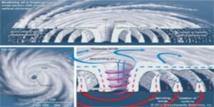
- Characteristic features of tropical cyclones are the eye, a central region of clear skies, warm temperatures, and low atmospheric pressure; the eyewall, the most dangerous and destructive part where winds are strongest and rainfall is heaviest; and rainbands, secondary cells that spiral into the center of the storm.
Further reading: https://journalsofindia.com/cyclone-emnati/


