Manifest pedagogy:
Climate change events cause erratic spatial and temporal variability in rainfall, temperature, humidity, etc..These events affect irrigation, domestic and industrial water supply. Water availability is under pressure due to climate change on one hand and there is overexploitation of water resources on the other. To overcome such problems, interlinking of rivers is one of the suitable alternatives.
Static dimensions:
- What is Interlinking of rivers?
- Drought prone Areas of India
- Flood Prone Areas of India
Current dimensions:
- Plan on River Linking
- Advantages of River Linking
- Disadvantages of River Linking
- Recent river links established
- Best practices in the world on interlinking
- National Interlinking of Rivers Authority (NIRA)
Content:
What is Interlinking of rivers?
- Interlinking of rivers refers to the water transfer from water surplus rivers to the water deficit rivers or regions.
- Brahmaputra and Ganga rivers particularly their northern tributaries, Godavari, Mahanadi and West Flowing rivers originating from the Western Ghats of India are found to be surplus in surface water resources.
- The initial plan to interlink India’s rivers came in 1858 from a British irrigation engineer, Sir Arthur Thomas Cotton.
- However, the idea of interlinking Indian rivers was revived a few decades ago independently by M. Visveswarayya, K. L. Rao and D.J. Dastur.
- In 1982, National Water Development Agency (NWDA) was set up as an autonomous organization under the Ministry of Irrigation with the aim to carry out detailed studies, surveys and investigations of the water balance and feasibility studies of the river interlinking projects.
- In 2002, the Government of India declared a substantial plan for an Inter-basin Water transfer (IBWT) program involving 30 links of different river basins of peninsular and the Himalayan parts of India.
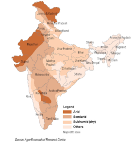
Drought prone areas of India-
- About 42% of India’s land area is drought prone, according to the Drought Early Warning System (DEWS), a real-time drought monitoring platform.
- Andhra Pradesh, Bihar, Gujarat, Jharkhand, Karnataka, Maharashtra, parts of the North-East, Rajasthan, Tamil Nadu and Telangana are the worst hit.
- These states are home to 500 million people, almost 40% of the country’s population.
- The parts of the country facing drought have been divided into six categories — Exceptionally Dry, Extremely Dry, Severely Dry, Moderately Dry, Abnormally Dry and No Drought, as per DEWS.
- The area in Extremely and Exceptionally dry categories is 11% of the entire country (as of 2019).
Flood Prone areas of India-
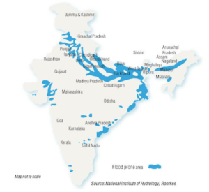
- In India, an average of 40 million hectares or 12 percent of the total land is flood prone, as per the SAARC Disaster Management Centre.
- Every year, about 8 million hectares in India is affected by floods.
- The most flood prone region of the nation is the basin of the Himalayan rivers covering parts of Punjab, Haryana, Himachal Pradesh, Delhi, Rajasthan, Uttar Pradesh, Bihar and West Bengal.
- Another flood prone region is the north-western river basin and Central and Peninsular river basins of Narmada, Tapi, Chambal and Mahanadi.
- Heavy floods often occur in the Godavari, Krishna, Pennar and Cauvery.
Plan on river linking-
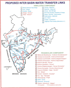
- The National River Linking project (NRLP) has two components: the peninsular and the Himalayan.
- The peninsular part of India covers the rivers in southern India envisaged developing a “Southern Water Grid” with 16 important river linkages in different states.
- This part included diversion of the excess waters of Godavari and Mahanadi to the Krishna, Cauvery, Pennar and Vaigai rivers.
- The 4 sub-components are
(1) Network of Mahanadi-Godavari-Krishna-Cauvery-Vaigai rivers;
(2) Network of west flowing rivers lies between south of Tapi and north of Bombay;
(3) Network of Parbati-Kalisindh-Chambal and Ken-Betwa rivers and
(4) diverting the flow in some of the west flowing rivers to the eastern side of the country.
- The Himalayan part of the India was conceived for building storage reservoirs on the Ganga and the Brahmaputra and their main tributaries
- The Himalayan part of India comprises 14 inter basin water transfer networks.
- It has two sub-components:
(1) Transfer of Ganga and Brahmaputra rivers surplus waters to the Mahanadi Basin and from Mahanadi to Godavari, Godavari to Krishna, Krishna to Pennar and Pennar to the Cauvery river basins.
(2) Transfer of water from the Eastern Ganga tributaries to the western sects of the Ganga and the Sabarmati river basins.
Since 2015, the Indian Government has implemented river interlinking projects in several segments such as the Godavari-Krishna river interlinking in Andhra Pradesh and the Ken-Betwa rivers interlink in Madhya Pradesh.
Advantages of River Linking-
- As Indian agriculture is ‘Gambling with monsoons’, the major benefit will be taken by the farmers who need not depend on the untimely rains for agricultural processes.
- The problems of floods and droughts would be tackled nationwide. E.g. The Ken Betwa link has been constructed that would help in supplying water to certain drought-prone areas.
- Social problems like deforestation, low water availability and no irrigation facilities can be solved.
- The poor section would be given drinkable water with greater equity.
- Many poor farmers will be able to use their lands if they are not using due to the irrigation crisis.
- If storage reservoirs can be built on these rivers and connected to other parts of the country, regional water imbalances could be reduced.
- Many benefits by way of industrial and domestic water supply, hydropower generation, waterways facilities, etc. would be ensured.
- Use of the surplus water which is otherwise flowing into the sea can be utilized.
Disadvantages of River Linking-
- The construction of canals, reservoirs, dams to complete the project might be very deteriorating for nearby vegetation and natural habitat. E.g. Ken-Betwa link leads to flooding of 10% of Panna Tiger reserve thus affecting wildlife.
- There is a possibility of a change in rainfall pattern as the marine ecosystem will be disturbed and the physical process for the rainfall will be affected.
- A study of Indian Institutes of Technology, Mumbai and Indian Institutes of Technology, Chennai reported that rainfall of the country has decreased over the years 1901–2004, reducing water storage even in the river basins that have surplus water.
- Reconstruction and rehabilitation caused due to displacement resulting from the implementation of the projects will involve social cost as well.
- State water disputes will lead to social unrest.
- Linking rivers having international boundaries may affect relations with neighbouring countries.
- Spread of endemic diseases is also a cause of concern.
Recent river links established-
Ken-Betwa River linking Project (RLP)-
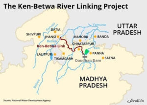
- Recently, Chief Ministers of Madhya Pradesh and Uttar Pradesh signed a memorandum of agreement to implement the Ken Betwa Link Project (KBLP).
- KBLP is the River interlinking project that aims to transfer surplus water from the Ken river in MP to Betwa in UP to irrigate the drought-prone Bundelkhand region.
- The region spread across the districts of two states mainly Jhansi, Banda, Lalitpur and Mahoba districts of UP and Tikamgarh, Panna and Chhatarpur districts of MP.
- The project involves building a 77-metre tall and a 2-km wide Daudhan dam and a 230-km canal.
- River linking will be a solution to recurring droughts in Bundelkhand region and will curb the rate of farmers suicide.
- It helps in reducing excessive dependence on groundwater and will accelerate the water conservation by construction of a multipurpose dam.
Kosi-Mechi Interlinking project-
- This is the second major river interlinking project in the country to be approved by the Central Government after the Ken-Betwa project in Madhya Pradesh.
- The river Kosi is an international river originating from Tibet and flowing through Nepal in Himalayan Mountains and the lower portion through plains of North Bihar.
- To overcome the acute problem of shifting of course to the Kosi river, heavy sediment load, flooding etc…the then Government of Nepal and the Government of India signed an agreement on 25th April 1954 for implementation of Kosi project.
- The present proposal is an extension of Eastern Kosi Main Canal (EKMC) system upto river Mechi, a tributary of river Mahananda.
- The aim of extension of EKMC upto Mechi river is mainly to provide irrigation benefits to the water scarce 2.14 lakh hectares of Mahananda basin command in the districts of Araria, Kishanganj, Purnia and Katihar during kharif season depending upon the pondage available in Hanuman Nagar barrage.
- This intrastate link scheme will thus transfer part of surplus water of Kosi basin to Mahananda basin.
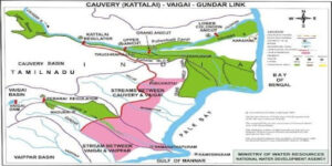
Cauvery – Vaigai – Gundar link-
- Cauvery–Vaigai Link Canal Project is a project envisioned by the Government of Tamil Nadu, linking Kaveri and Vaigai rivers, which would benefit the state during the drier seasons.
- Project involves construction of a 60-kilometre long canal from Mayanur in Karur district to link river Kaveri with Vaigai.
- The gravity canal will provide water for irrigating an additional area of 3.38 lakh hectares and for domestic and industrial water supply.
- The project lies entirely in Tamil Nadu State.
- This link is an integral part of the Mahanadi – Godavari – Krishna -Pennar – Cauvery – Vaigai – Gundar link, which envisages transfer of surplus Mahanadi and Godavari waters that would be brought into the Krishna river to Pennar and from there to Palar, Cauvery, Gundar etc.
Periyar river project-
- The project was started in 1895 with the aim to provide irrigation facilities to water deficit Vaigai river basin.
- The project envisages the transfer of water from Periyar river basin to Vaigai river basin.
- A masonry gravity dam at Periyar river has been constructed across a gorge on west flowing.
- There is also a hydropower station of 140 MW capacities.
Polavaram project-
- It is also called the Indira Sagar project.
- It is a multipurpose project built on Godavari river to transfer surplus water to river Krishna in the state of Andhra Pradesh.
- It has an assessed culturable command area (CCA) of 2.91 lakh hectares and hydropower generation capacity of 960 Mega Watt (MW).
- It additionally has a carrying capacity of drinking water supply of 23.44 thousand Million Cubic Feet (TMC) to Visakhapatnam Steel Plant.
Best Practices in the world on river interlinking-
- South-north water transfer project, China— An ambitious plan to link Yangtze river basin in the south with the yellow river basin in the north, construction of the South-north water transfer project (SNWTP) began in 2002.
- Tagus-Segura transfer project, Spain— This project was completed in 1978 that connects four river basins Tagus, Jucar, Segura and Guadiana, to irrigate 1.7 lakh hectares and provide water to 76 municipalities in south eastern Spain.
- Lesotho highlands water projects, South Africa — This project was started in 1950 and completed in 1986 by South Africa and its neighbor Lesotho, the project involves transferring water from the upper reaches of the Orange river in Lesotho to the Vaal river in South Africa, and also generate hydel power.
- California’s State Water Project, United States– It diverts 4 km3 of water from excess watered northern California to the drier central and southern parts.
National Interlinking of Rivers Authority (NIRA)-
- NIRA will be an independent autonomous body for planning, investigation, financing and the implementation of the river interlinking projects in the country.
- It will replace the existing National Water Development Agency (NWDA) and will function as an umbrella body for all river linking projects.
- It will be headed by a Government of India Secretary-rank officer.
- The new body will coordinate with neighbouring countries and concerned states and departments and will also have powers on issues related to environment, wildlife and forest clearances under river linking projects and their legal aspects.
- It will have the power to raise funds and act as a repository of borrowed funds or money received on deposit or loan given on interest.
- It will have the power to set up a Special Purpose Vehicle (SPV) for individual link projects.
Mould your thought:
- Though interlinking of rivers is a way for sustainable usage of water, it has its own cons that may be disastrous. Comment.
Approach to the answer-
- Briefly define interlinking of rivers
- Explain the disadvantages
- Write the advantages with examples
- Conclusion


