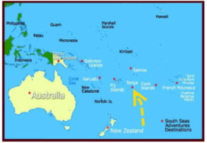
In news– Recently, the underwater volcano Hunga Tonga-Hunga Haʻapai erupted, triggering a tsunami that flooded Pacific coastlines from Japan to the U.S.
More information-
- Hunga-Tonga-Hunga-Ha’apai, which lies about 65 kilometres north of Nuku’alofa, has a history of volatility.
- A volcanic eruption merged the two islands of Hunga Tonga and Hunga Haʻapai in 2009, and a more explosive eruption separated the islands and reduced them in size.
- The recent eight minute volcanic eruptions triggered tsunami waves around the Pacific caused “significant damage” to the island nation Tonga’s capital Nuku’alofa and smothered it in dust.
- The US Geological Survey recorded the eruption as equivalent to a 5.8-magnitude earthquake at zero depth.
- The volcano is part of the highly active Tonga–Kermadec Islands volcanic arc, a subduction zone extending from New Zealand north-northeast to Fiji.
- The island arc is formed at the convergent boundary where the Pacific Plate subducts under the Indo-Australian Plate.

About Tonga-
- It is an island nation and a Polynesian country and also an archipelago consisting of 169 islands divided into three main groups – Vava’u, Ha’apai, and Tongatapu.
- It lies 2,383 kilometres northeast of New Zealand.
- Tongan is the official language, along with English.
- It is surrounded by Fiji and Wallis and Futuna (France) to the northwest; Samoa to the northeast; New Caledonia (France) and Vanuatu to the west; Niue (the nearest foreign territory) to the east; and Kermadec (New Zealand) to the southwest.
- Tonga has a tropical rainforest climate (Af) with a distinct warm period (December–April).
- Tonga became a protected state under a Treaty of Friendship with Britain on 18 May 1900 and the treaty ended in 1970.
- Tongans, Polynesian by ethnicity with a mixture of Melanesian, represent more than 98% of the inhabitants.
Source: BBC


