All elephant corridors across India are affected by development activities and human interference in one way or the other. In this context, the Madras High Court directing the State government and the Principal Chief Conservator of Forests (PCCF) to come up with a plan to ensure the right of passage to elephants and, consequently, avoid frequent man-animal conflicts in Coimbatore forest division, gains importance from UPSC point of view.
- Habitat Fragmentation
- Elephant Corridors and different wildlife corridors in India
- Green Highways
- Global Best Practices
Content:
Habitat Fragmentation:
- Habitat fragmentation is that process that cuts big habitats into smaller pieces of land that get isolated from each other.
- Each of these pieces constitutes a habitat by itself, but they no longer interact with each other like they did when they were all part of the same ecosystem.
- Habitat fragmentation is not only responsible for change in the characteristics of a fragment but also causes extinction of many species.
- To put it simply, Habitat Fragmentation is like a wall between a species and its food or place of reproduction.
- This prevents the species in question from reaching these vital places, which threatens their survival skills.
- The creatures should adapt to the new conditions, and find ways to survive without some important resources.
- These changes they need to undergo can be too drastic, as they might suffer a forced evolution. In many cases, the creatures cannot adapt to these conditions, so their numbers suffer massive drops.
- Whenever a region suffers habitat fragmentation, the edge effect occurs. This means the newly created edge of the habitat becomes less friendly for the species that populate it.
- As a result, they start withdrawing towards the center, so the living space gets even smaller.
- This crowding effect is bad for all the species as well, as they no longer enjoy the same living conditions.
Causes of Habitat Fragmentation include the following:
1. Natural Causes
- Habitats can be fragmented because of numerous natural reasons.
- Out of them, volcanic eruptions, fire, and change in climate are the three major natural factors that lead to the onset of habitat fragmentation.
2.Man Made causes
- Humans are directly responsible for rapid and fast habitat fragmentation.
- Some of the ways in which humans trigger fragmentation are urbanization, rural development and claiming new agricultural lands, logging and cutting down forests, construction of roads and railway tracks, development of housing projects, building water reservoirs and so on.
- Recently, the Supreme Court (SC) upheld the 2011 order of the Madras High Court (HC) on the Nilgiris elephant corridor, affirming the right of passage of the animals and the closure of resorts in the area.
- In 2011, the Madras HC upheld the validity of the Tamil Nadu government’s notification (of 2010) declaring an ‘Elephant Corridor’ in the Sigur Plateau of Nilgiris District.
- It said that the government is fully empowered under the ‘Project Elephant’ of the Union government as well as Article 51 A(g) of the Constitution to notify the elephant corridor in the state’s Nilgiris district.
- Article 51 A(g) states that, it shall be the duty of every citizen of India to protect and improve the natural environment including forests, lakes, rivers and wildlife and to have compassion for living creatures. (Fundamental Duties)
- Further, it upheld directions to the resort owners and other private landowners to vacate lands falling within the notified elephant corridor.
- It’s the State’s duty to protect a “keystone species” like elephants, which are immensely important to the environment.
- Keystone species, in ecology, a species that has a disproportionately large effect on the communities in which it lives.
- Elephant corridors allow elephants to continue their nomadic mode of survival, despite shrinking forest cover, by facilitating travel between distinct forest habitats. These corridors play a crucial role in sustaining wildlife by reducing the impact of habitat isolation.
- The court also allowed the formation of a committee led by a retired HC judge and two other persons to hear the individual objections of resort owners and private landowners within the corridor space.
- However, during the hearings, the SC opined that the area is a fragile ecosystem, where the will of men must give way to elephants.
Elephant Corridors and different wildlife corridors in India:
- Wildlife corridors, used by various species to migrate, breed and feed, are increasingly becoming relevant as essential tools for wildlife conservation.
- A wildlife corridor, habitat corridor, or green corridor is an area of habitat connecting wildlife populations separated by human activities or structures (such as roads, development, or logging).
- This allows an exchange of individuals between populations, which may help prevent the negative effects of inbreeding and reduced genetic diversity (via genetic drift) that often occur within isolated populations.
- Corridors also help facilitate the re-establishment of populations that have been reduced or eliminated due to random events (such as fires or disease).
- This may potentially moderate some of the worst effects of habitat fragmentation, wherein urbanization can split up habitat areas, causing animals to lose both their natural habitat and the ability to move between regions to use all of the resources they need to survive.
- Habitat fragmentation due to human development is an ever-increasing threat to biodiversity, and habitat corridors are a possible mitigation.
- There are about 100 elephant corridors in India of which almost 70% are used regularly.
- 75% of the corridors are in the southern, central and north-eastern forests.
- There are an estimated 6,500 elephants in just the Brahmagiri-Nilgiris-Eastern Ghats ranges.
Some of the important Wildlife corridors in India are as follows:
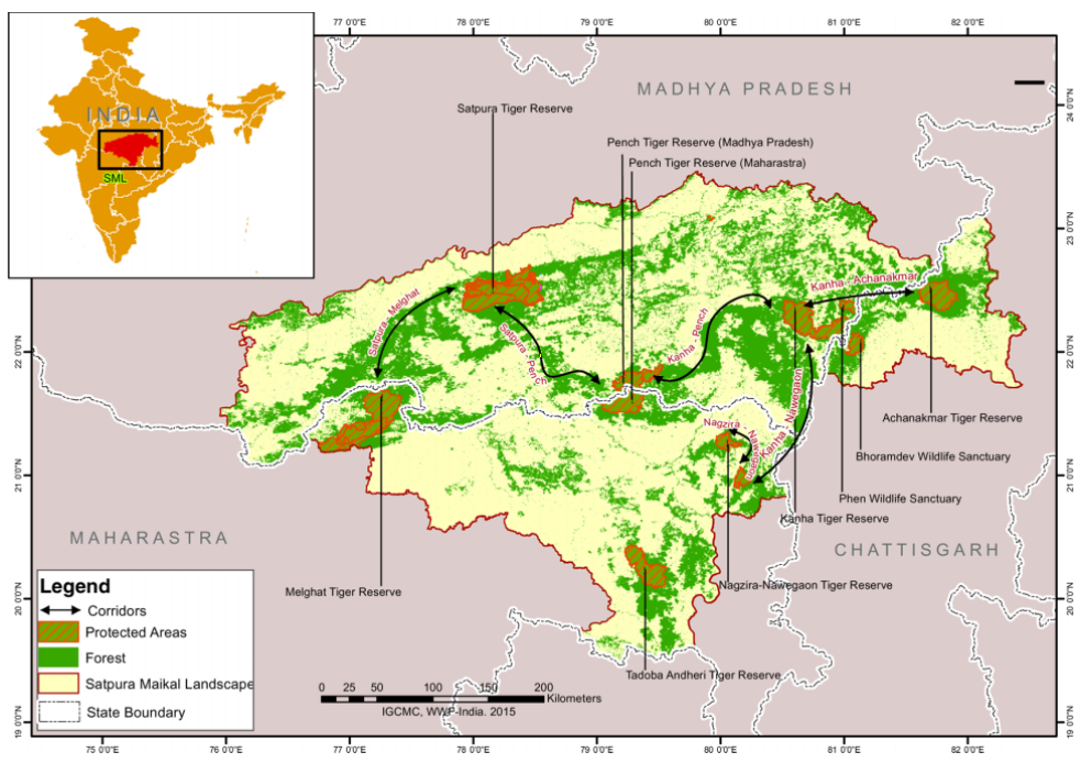
1. Kanha Pench corridor in the Satpura Maikal Landscape
- Central India holds a large percentage of the tiger population and the Satpura Maikal Landscape (‘SML’) is a global priority landscape for tiger conservation.
- The area is rife with development, infrastructure and mining projects leading to widespread habitat fragmentation.
- The Kanha-Pench (K-P) corridor complex harbours around 120 tigers creating a healthy metapopulation of tigers in central India, along with other critical flora and fauna. The landscape also supports diverse land use, forest protection regimes and traditional forest-dwelling tribal communities
- Human–wildlife conflict is not the biggest threat in the region.
- The functional status of various corridors within central India is rapidly declining with increased threats of development projects, linear infrastructure and the changing socio-economic status of the communities living within and around the corridors
- Infrastructure development in the last decade has become a major threat to the corridor. National Highway-7 (NH 7) is a major barrier for animal movement in the corridor. Numerous road-kill accidents have been documented in the area,
- Another threat to the K-P corridor is the proposed broadening of a narrow-gauge railway track from Nainpur to Balaghat; this will severely impact the corridor.

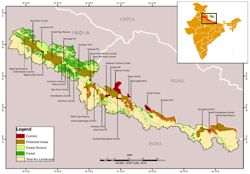
2. Kilpura Khatima Surai Corridor in the Terai Arc Landscape
- The Terai Arc Landscape (‘TAL’) spreads across 810 km of the Indian states of Uttarakhand, Uttar Pradesh and Bihar, and the low-lying hills of Nepal.
- The landscape boasts of some of India’s most well-known Tiger Reserves and Protected Areas such as Corbett Tiger Reserve, Rajaji National Park, Dudhwa Tiger Reserve, Valmiki Tiger Reserve and Nepal’s Bardia Wildlife Sanctuary, Chitwan National Park, and Sukhla Phanta Wildlife Sanctuary.
- In total, the landscape has 13 Protected Areas (PAs), nine in India and four in Nepal
- The Kilpura Khatima Surai (‘KKS’) is a critical corridor that connects Corbett National Park to other source areas.
- It is the only tiger corridor that connects Uttarakhand and Uttar Pradesh and the last remaining connectivity between the tiger populations of lower Himalayas and Terai.
- Apart from being a priority tiger corridor, KKS is also among the ‘Priority II Elephant corridors’
- The region has seen rapid transformation from dense wilderness and malarian forests, into a largely agrarian area with a densely populated landscape dominated by fields of wheat, rice and sugarcane, interspersed with roads and railway networks.
- Today less than two per cent of the contiguous natural habitat remains protected as PAs.
- As the needs of a growing economy increase, protection of wildlife corridors now rests on mitigation measures like over and under passes to ease the movement of wildlife.

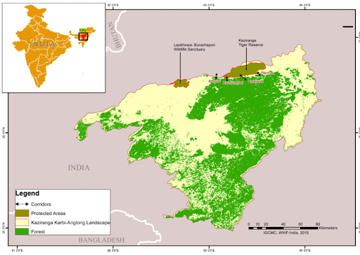
3. Kaziranga–Karbi Anglong Landscape
- The Kaziranga–Karbi Anglong Landscape (KKL) in the central part of Assam is an area.
- It connects Kaziranga National Park (KNP) and Karbi Anglong (KA) hills forming a critical corridor network.
- KNP is a world heritage site and home to two-thirds of the world’s population of the one horned rhino
- NH 37, which divides the low-lying areas of Kaziranga and the hills of Karbi Anglong is one of the primary concerns in KKL.
- Assam receives a lot of rainfall during the monsoons, and each year KNP is flooded forcing wildlife to take refuge in the Karbi Anglong Hills southwards, which is across the highway.
- A number of animals are killed on the road each year due to speeding traffic.
- While judicial intervention has led to a considerable decline in encroachments and illegal construction in the landscape.
- However, a faulty environment and forest clearance system needs to be evaluated by the state authorities.

- The corridor is situated in the ecologically fragile Sigur plateau, which connects the Western and the Eastern Ghats and sustains elephant populations and their genetic diversity.
- It is situated near the Mudumalai National Park in the Nilgiris district.
- It has the Nilgiri hills on its southwestern side and the Moyar river valley on its northeastern side. The elephants cross the plateau in search of food and water.
Green Highways:
- A green highway is a roadway constructed per a relatively new concept for roadway design that integrates transportation functionality and ecological sustainability.
- An environmental approach is used throughout the planning, design, and the construction.
- The result is a highway that will benefit transportation, the ecosystem, urban growth, public health and surrounding communities.
- Structures like wildlife crossings along the roadways allow animals to cross human-made barriers safely.
- Micro-forests and urban forests are also created near the highways and roads.
Global Best Practices:
- Restoration beyond the borders of a protected area may be needed to foster links between isolated protected areas: an application of connectivity conservation
- This is regularly achieved through large corridors.
- Connectivity conservation in large corridors recognizes and promotes the following:
- landscape connectivity (the spatial interconnectedness of vegetation),
- habitat connectivity (connectivity which focuses on the habitat needs of certain species),
- ecological connectivity (which focuses on connectivity that facilitates ecosystem function) and
- evolutionary process connectivity (which emphasizes the retention of opportunities for the retention of species)
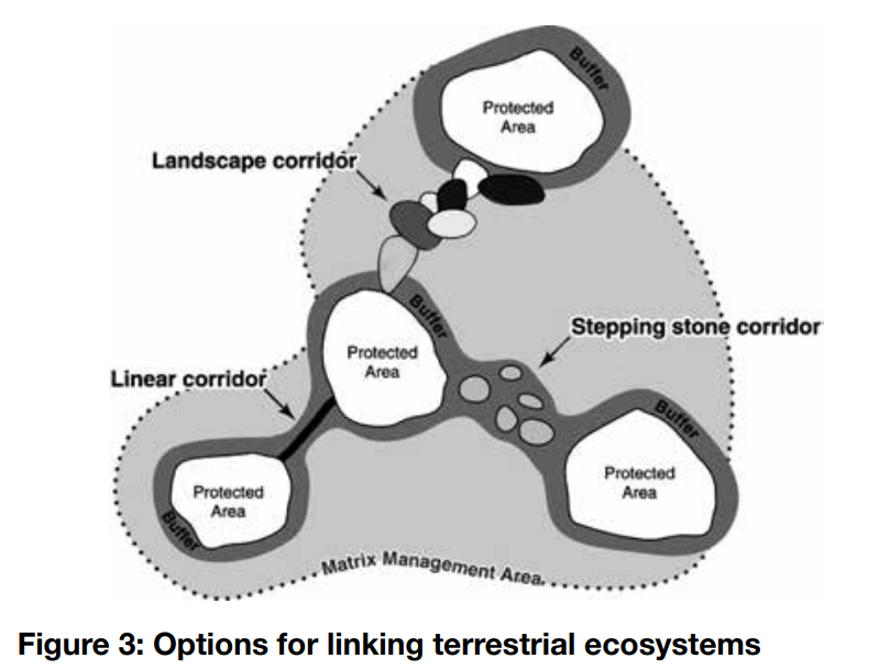
- Buffer zones adjacent to or around protected areas: to embed a protected area in a landscape or seascape that will support conservation: e.g., negotiating with farmers to switch to shade-based coffee to provide forage opportunities for woodland birds
- Corridor linkages between protected areas: to allow movement of species and thus genetic interchange and migration of ranges as species adapt to a changing climate: e.g., working with service providers, real-estate developers, forest managers or farmers to ensure the restoration of linking corridors of trees or other suitable vegetation. Most corridor analyses are based on current habitat, but restoration scientists can sometimes identify the effort required to restore degraded areas, thus increasing opportunities for connectivity in such analyses.
- Ecological stepping stone linkages between protected areas (often these are parts of corridors): to ensure that migratory mammals, birds and insects have resting and feeding locations spaced so as to ensure their safe passage.
- Landscape/seascape mosaic: to link various habitats into a viable and more functional ecosystem. This involves planning at a larger scale to make sure that there are no important elements missing from the ecosystem and restoring them when necessary.
Evaluation of these measures
- Connectivity conservation goals inspire additional challenges for restoration, and external partnerships are usually needed such as protected area managers working with other managers, communities and landowners, and particularly with those authorities that govern land/water-use planning and decision-making.
- In practice, success or failure usually rests on the extent to which communities and stakeholders are actively engaged.
- Support is often built gradually, through stakeholder engagement, honest explanation of the costs and benefits, and the personal relationships that grow up over time
- In general, efforts to restore the structure, function, and composition of reference habitats, and to remove or overcome barriers to movement such as dams, highways and high density development will contribute to landscape and seascape connectivity.
- Restoration performance outcomes may also be assessed as part of a larger corridor management effectiveness assessment.

Protected area: A clearly defined geographical space, recognized, dedicated and managed, through legal or other effective means, to achieve the long-term conservation of nature with associated ecosystem services and cultural values
- Introduction
- Define Habitat Fragmentation
- Mention its harmful effects
- Give examples from Indian context
- Write about restorative measures for enhancing connectivity
- Conclusion


