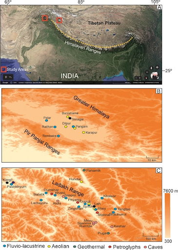
In news– Researchers investigating sedimentary landforms present in parts of the Kashmir Valley and Ladakh regions of the NW Trans-Himalaya have found them to be a repository of palaeoclimatic records of Himalayan tectonics and geomorphic evolution of the scenic landscape.
Key findings-
- A research by Birbal Sahni Institute of Palaeosciences (BSIP), an autonomous institute of DST that studied the Quaternary (current and most recent of the three periods in the geologic time scale), sediments of Karewa Basin in Kashmir valley and deposits relating to sedimentation partly in lake and partly in stream waters of Ladakh Trans-Himalaya) has highlighted the importance, possible threats and well as the need for conservation and promotion of the Geoheritage sites.
- The panoramic Geotourism sites in the Himalayan range are an archive of palaeoclimatic records of Himalayan tectonics and geomorphic evolution of this scenic landscape.
- Consisting of lake sediments, caves, petroglyphs/rock art, and hot springs sites, they are a treasure trove of information on geomorphology, landscape evolution, palaeoclimate, and palaeoecology.
- The neo-tectonics of this recent period is helpful in the understanding of climate change, hydroclimate, ecology, and mountain geomorphology.
- At the same time, the Ladakh sediment archive is along the Indus River in the form of fluvial terraces, alluvial fans, lakes, and moraine and are exposed under a wide range of tectonics, seasonal climatic changes, mass wasting, erosion, and major development projects regimes.
- The authors have underlined that changing climatic conditions, ongoing mountain building (tectonic/orogenic) processes, and anthropogenic activities are continuously destroying these Geosites; hence, the associated geo-resources need to be harnessed sustainably.

- Geosites of Ladakh under threat-(A) Stone dumping at rock art site at Stakna; (B) Wall painting inside a cave in Saspol, many of these caves are collapsing; (C, E, G) Keshar, Sumdo caves used as storage; (D, I) Car wash and construction work on the Spituk palaeolake site; (H) Building on the fluvial section in Pashkyum; (J) Shachukul section; (K) Roadside rock art destroyed by tar (L) Mining of sand for construction work in Spituk section; (M) Shey palaeolake section (N) Puga hot spring, the lingam is breaking as there is no protection of site; (O) Shachukul site.
What is Paleoclimatology?
It is the study of climates for which direct measurements were not taken. As instrumental records only span a tiny part of Earth’s history, the reconstruction of ancient climate is important to understand natural variation and the evolution of the current climate.


