In News
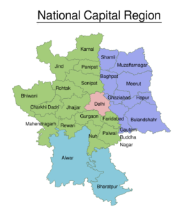
The National Capital Region (NCR) in India is the country’s largest and one of the world’s largest agglomerations, with a population of over 47,000,000. The National Capital Region in India encompasses the entire National Capital Territory of Delhi, which includes New Delhi, as well as urban areas surrounding it in neighboring states of Haryana, Uttar Pradesh and Rajasthan.
More About NCR
- Districts in three neighbouring states of Haryana, Uttar Pradesh and Rajasthan, along with whole of the National Capital Territory of Delhi constitute the National Capital Region (NCR) of India, as defined in National Capital Region Planning Board (NCRPB) Act, 1985
- Delhi: Delhi constitutes about 2.9% of the land area of the region.
- Areas under Uttar Pradesh: Meerut, Ghaziabad, Gautam Budh Nagar, Bulandshahr, Baghpat, Hapur and Muzaffarnagar.
- Areas under Haryana: Faridabad, Gurgaon, Mewat, Rohtak, Sonipat, Rewari, Jhajjar, Panipat, Palwal, Mahendragarh, Bhiwani, Jind and Karnal.
- Areas under Rajasthan: Bharatpur and Alwar.
- National Capital Region (NCR) is a unique example of inter-state regional planning and development constituted with the key rationale to promote balanced and harmonized development of the region and to avoid any haphazard development.
Functions of National Capital Region Planning Board
- To co-ordinate the enforcement and implementation of the regional plan, functional plans, sub-regional plans and project plans through the participating states and the NCT, Delhi
- To ensure proper and systematic programming by the participating states and the NCT Delhi in regard to project formulation and phasing of development of the National Capital Region in accordance with stages indicated in the regional plans.
- To arrange for, and oversee, the financing of selected development projects in the NCR through central and state plan, funds and other sources of revenue.


