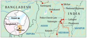
In news
For the first time since last week’s violence along the Assam-Mizoram border, the two states’ chief ministers attempted to defuse tensions between their people and security forces.
History of the dispute
- The boundary dispute between Assam and Mizoram dates back nearly a century and a half.
- The boundary between the two states, which runs 164 km today, has a history dating back to the time when Mizoram was a district of Assam and known as Lushai Hills.
- Mizoram borders Assam’s Barak Valley, and both border Bangladesh.
- Three districts in Assam – Cachar, Hailakandi and Karimganj – share a 164km-long border with three districts of Mizoram.
- Boundary demarcations in 1875 and 1933, particularly the second one, are at the heart of the dispute.
- The 1875 demarcation, notified on August 20 that year, derived from the Bengal Eastern Frontier Regulation (BEFR) Act, 1873.
- It differentiated Lushai Hills from the plains of Cachar in Assam’s Barak Valley.
- This was done in consultation with Mizo chiefs, and it became the basis for the Inner Line Reserve Forest demarcation in the Gazette two years later.

- The 1933 demarcation marks a boundary between Lushai Hills and Manipur, beginning at the tri-junction of Lushai Hills, Cachar district and Manipur.
- The Mizos do not accept this demarcation on the ground that their chiefs were not consulted this time.
- The dispute has been simmering since Mizoram became a Union Territory in 1972 and then a state in the 1980s.
- The first row broke out in 1994, seven years after Mizoram became a state.
- The Union government organised several rounds of talks between the two states to resolve the boundary dispute but tensions remained.
- Tensions escalated to an unprecedented level in October 2020 when residents of Assam and Mizoram clashed twice in a week.
- Residents of both states clashed twice and the national highway linking them was blocked for several days.
- This year, tensions have peaked after the clashes between the police forces of the states at the contentious border point Lailapur.
Mizoram’s claims
- According to Mizo leaders, the only acceptable boundary is the Inner Line of 1875 on the southern frontier of Cachar, notified as per the BEFR Act(revised in 1878).
- The leaders say that the present boundary was arbitrarily made in 1930 and 1933 without the consent and approval of the competent authorities and the people of the Lushai Hills, now Mizoram.
Assam’s claims
- It says tha Mizoram began constructing a road towards Rengti Basti in Assam, destroying the Inner Line Reserve Forest in Lailapur area.
- Mizoram side also set up a new armed camp on a hillock next to the camp of the neutral force, CRPF, in the same vicinity.
- While Assam sees its claimed boundary as transgressed, Mizoram cites unilateral moves by Assam inside Mizoram territory.
Other border disputes in the region
- Assam, which shares its boundary with all other Northeast states and from which states such as Nagaland, Meghalaya and Mizoram were carved out, has been involved in disputes with several of its neighbours.
- Assam and Nagaland share a 500-km boundary.
- Violent conflicts, some leading to deaths, have taken place in several phases since 1965.
- With Arunachal Pradesh, Assam shares an around 800-km boundary. Here, the first clashes were reported in 1992.
- With Meghalaya, Assam shares a boundary of 884 km.
- There has been a series of recent flare-ups here, too.
- The Meghalaya government claims it has 12 areas of disputes with Assam.


