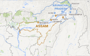
In news– Fresh tensions were reported along the inter-state border of Assam and Arunachal Pradesh (at Likabali-Durpai road) even after chief ministers of both the states met to discuss a “permanent solution” over the decades-old boundary dispute recently.
History of border dispute-
- The dispute dates back to colonial times, when the British in 1873 announced the “inner line” regulation, demarcating an imaginary boundary between plains and the frontier hills, which were later designated as the North East Frontier Tracts in 1915.
- The latter corresponds to the area that makes up present-day Arunachal Pradesh.
- Arunachal Pradesh, which was earlier a part of Assam, shares a boundary of 804.1 km with the state.
- After Independence, the Assam government assumed administrative jurisdiction over the North East Frontier Tracts, which later became the North East Frontier Agency (NEFA) in 1954, and finally, the Union Territory in 1972.
- It gained statehood in 1987.
- However, before it was carved out of Assam, a sub-committee headed by then Assam chief minister Gopinath Bordoloi made some recommendations in relation to the administration of NEFA (under Assam) and submitted a report in 1951.


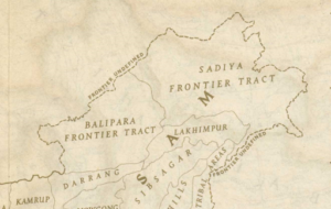
- Based on the Bordoloi committee report, around 3,648 sq km of the “plain” area of Balipara and Sadiya foothills was transferred from Arunachal (then NEFA) to Assam’s then Darrang and Lakhimpur districts.
- This remains the bone of contention between the two states as Arunachal Pradesh refuses to accept this notification as the basis of demarcation and holds that the transfer was done without the consultation of its people.
- Assam, on the other hand, feels that this demarcation as per 1951 notification is constitutional and legal.
- Between 1971 and 1974, there were multiple efforts to demarcate the boundary but it did not work out.
- In April 1979, a high-powered tripartite committee was constituted to delineate the boundary on the basis of Survey of India maps, as well as discussions with both sides.
- By 1983-84, out of the 800 km, 489 km, mostly in the north bank of the Brahmaputra, were demarcated.
- However, further demarcation could not commence because Arunachal Pradesh did not accept the recommendations, and claimed several kilometers out of the 3,648 sq km that was transferred as per the 1951 notification.
- Assam objected and filed a case in the Supreme Court in 1989, highlighting an “encroachment” made by Arunachal Pradesh, while seeking demarcation of the boundary between the states.
- To resolve the dispute between the two states, the apex court-appointed a local boundary commission in 2006, headed by a retired SC judge.
- In September 2014, the local commission submitted its report and several recommendations were made (some of which suggested Arunachal Pradesh get back some of the territory which was transferred in 1951), and it was suggested that both states should arrive at a consensus through discussions. However, nothing came of it.
Further reading: https://journalsofindia.com/?s=border+dispute


