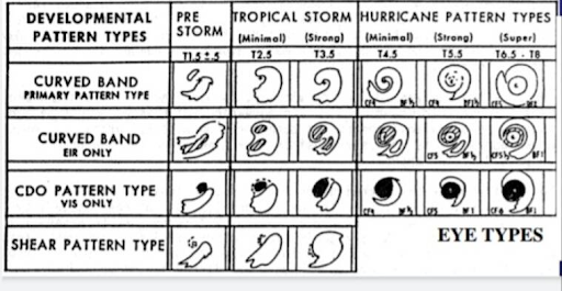
In news– The American meteorologist Vernon Dvorak, best credited for developing the Dvorak (read as Do-rak) technique has passed away at the age of 100.
What is Advanced Dvorak Technique (ADT)?
- It was first developed in 1969 and tested for observing storms in the northwest Pacific Ocean.
- Forecasters used the available satellite images obtained from polar orbiting satellites to examine the features of the developing tropical storms (hurricanes, cyclones and typhoons).
- During day time, images in the visible spectrum were used while at night, the ocean would be observed using infrared images.

- This technique was a cloud pattern recognition technique based on a concept model of the development and decay of the tropical cyclone.
- From the satellite images thus obtained, it helps forecasters to do a pattern recognition from the observed structure of the storm, locate its eye and estimate the intensity of the storm.
- Through this statistical technique, scientists are able to measure the cyclone’s convective cloud pattern — curved bands, eye and central dense or cold region and shear.
- It is the Dvorak technique which gives the best estimates of the cyclone intensity.
- This tool cannot help make any predictions, measure wind or pressure or any other meteorological parameters associated with the cyclone.
- The veteran meteorologist had also presented the wind speed and associated category of the tropical cyclone, making it a near-perfect tool for the operational cyclone forecasters.
Relevance of this technique-
- There are many vast regions across the four oceans that have not been fully examined with meteorological instruments. Ocean observations are mostly taken by deploying buoys or dedicated ships, but the number of observations from the seas is still not sufficient across the world.
- That is why meteorologists have had to depend more on satellite-based imageries, and combine it with the available ocean-data at the time of forecasting the intensity and wind speed of the tropical cyclones.
- The Dvorak technique, said to be one of the greatest meteorological innovations, has undergone several advancements since its inception. Even in the present day, when forecasters have access to several state-of-the-art tools like model guidance, animations, artificial intelligence, machine learning and satellite technology, it is the advanced versions of the 50-year-old technique that continues to be widely used.
Note:
- Dvorak was an American meteorologist best credited for developing the Dvorak (read as Do-rak) technique in the early 1970s.
- Dvorak was educated at the University of California, Los Angeles. His Master’s degree thesis in 1966 was titled ‘An investigation of the inversion-cloud regime over the subtropical waters west of California’. He worked with the National Environmental Satellite, Data, and Information Service of National Oceanic and Atmospheric Administration (NOAA).
- He was bestowed with the United States Department of Commerce Meritorious Service award in 1972. In 2002, he received a Special Lifetime Achievement Award from the National Weather Association.


