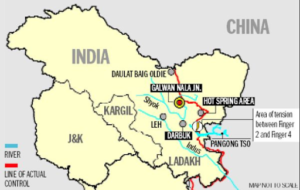
In news– Recently, Satellite imagery showed a second bridge was being built by China around the strategically key Pangong Tso Lake in eastern Ladakh.
The 2nd bridge & India’s response to it-
- China’s second bridge is located right next to the bridge it constructed earlier this year, in an area that lies along India’s claim line.
- The bridge is located around 20 km east of Finger 8 on the north bank of the lake, where India says is the point that marks the LAC. But by road, it would be over 35 km from Finger 8.
- The area has been under Chinese control since 1958, although it is just west of India’s claim line, which, according to India, is its international boundary.
- It is just east of a ruin named Khurnak Fort, where China has major frontier defence bases.
- The region is called Rutong County by China. China has a frontier defence company at the Khurnak Fort, and a water squadron further east at Banmozhang.
- The bridge is near the halfway mark of the boomerang-shaped, 135- km-long Pangong Tso. India has about 45 km of the lake under its control.
- The bridge could help the Chinese military to quickly mobilise its troops in the region.
- Indian Ministry of External Affairs said that both these bridges are in areas that have continued to be under the illegal occupation of China since the 1960s.
- It further said that India has not accepted China’s “unjustified claim” or “such construction activities”.
About the lake
- Pangong Tso is a long narrow, deep, endorheic (landlocked) lake situated at a height of more than 14,000 ft in the Ladakh Himalayas.
- In the Ladakhi language, Pangong means extensive concavity and Tso is a lake in Tibetan.
- It is situated at a height of almost 4,350m, and is the world’s highest saltwater lake.
- Its water, which seems to be dyed in blue, stand in stark contrast to the arid mountains surrounding it.

- Lake is also known to change colors, appearing blue, green and red at different times.
- It divided into five sub lakes, called Pangong Tso, Tso Nyak, Rum Tso (twin lakes) and Nyak Tso.
- The eastern part of the lake is fresh, with the content of total dissolved solids at 0.68 g/L, while the western part of the lake is saline, with the salinity at 11.02 g/L.
- During winter the lake freezes completely, despite being saline water. It becomes ideal for ice skating and polo.
- It is not a part of the Indus river basin area.
- One-third of the water body, its 45 km stretch is in Indian control while the rest of the 90 km is under Chinese control.
- In October 1962, Pangong Tso saw military action during the Sino-Indian War, successful for the Chinese People’s Liberation Army (PLA)
- In the 1990s, when the Indian side laid claims over the area, the Chinese army built a metal-top road contending that it was part of the Aksai Chin.
- The legendary 19th century Dogra general Zorawar Singh is said to have trained his soldiers and horses on the frozen Pangong lake before invading Tibet.
- An Inner Line Permit is required to visit the lake as it lies on the Sino-Indian Line of Actual Control.
- The lake acts as an important breeding ground for a variety of birds including a number of migratory birds. During summer, the Bar-headed goose and Brahmini ducks are commonly seen here.
- The region around the lake supports a number of species of wildlife including the kiang and the marmot.
Source: Times of India


