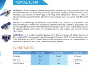
In news– The Indian Space Research Organization(ISRO) has successfully launched earth observation satellite EOS-04 with on board PSLV-C52 on February 14, which is the first mission of ISRO in 2022.
About EOS- 04 & PSLV-C52
- EOS-04 is a Radar Imaging Satellite designed to provide high quality images under all weather conditions for applications such as Agriculture, Forestry & Plantations, Soil Moisture & Hydrology and Flood mapping.
- It was launched from Satish Dhawan Space Center, Sriharikota Range (SHAR), Sriharikota.
- PSLV-C52 is designed to orbit an earth observation satellite (EOS-04), weighing 1710 kg into a sun synchronous polar orbit of 529 km.
- It was the 54th flight of PSLV and the 23rd flight of PSLV in the XL configuration (6 strap-on motors).
- PSLV-C52 mission will also carry two small satellites as co-passengers which includes
- One student satellite (INSPIREsat-1) from Indian Institute of Space Science & Technology (IIST) in association with Laboratory of Atmospheric & Space Physics at University of Colorado, Boulder and
- A technology demonstrator satellite (INS-2TD) from ISRO, which is a precursor to India-Bhutan Joint Satellite (INS-2B).

- EOS-04 is the fourth in a series of earth observation satellites that are being launched under a new generic name.
- Two years ago, ISRO had moved to a new naming system for its earth observation satellites which till then had been named thematically, according to the purpose they were meant for.
- However, only the first of these newly named satellites, EOS-01, launched in November 2020, is in orbit right now.
- EOS-02, a micro-satellite to be flown on a new launch vehicle called SSLV (Small Satellite Launch Vehicle) is yet to be launched, while launch of EOS-03 had ended in a failure in August 2021.
- EOS-04 would replace the RISAT-1 which was launched in 2012 but has been non-functional for the last few years.
- RISATs use synthetic aperture radars to produce high-resolution images of the land. One big advantage that radar imaging has over optical instruments is that it is unaffected by weather, cloud or fog, or the lack of sunlight.
- It can produce high-quality images in all conditions and at all times, making it suitable for surveillance.
- EOS-04 was designed to provide high-quality images for applications such as agriculture, forestry and plantations, flood mapping, soil moisture and hydrology.
- It will complement the data from Resourcesat, Cartosat and RISAT-2B series of satellites that are already in orbit.
- India currently has 53 operational satellites, of which 21 are earth observation ones and another 21 are communication-based. Eight are navigation satellites, while the remaining three are science satellites.


