In News: Recently, it has been reported that Nepal has proposed a meeting of the Boundary Working Group (BWG) in August end or early September 2020
Boundary Working Group (BWG)
- The BWG is a joint agency constituted by the governments of India and Nepal in 2014 to carry out works in the fields of construction, restoration and repair of boundary pillars including clearance of ‘no-man’s land’ and other technical tasks.
- Led by the Surveyor General of India, the BWG is different from the foreign secretaries meeting that is being sought to discuss the Kalapani border dispute, but it is an important mechanism to review the boundary work.
- Survey of India is the National Mapping Agency under the Department of Science & Technology.
- The group so far has held six meetings. The last meeting was on 28th August 2019 in Dehradun (Uttrakhand).
- In 2017, the two sides had finalised the comprehensive plan and modalities for execution and completion of boundary work in the next five years.
- The BWG’s inputs are critical as they are given to the governments on the basis of field-level survey.
- The 15th August phone call between the Prime Ministers, followed by the 17th August meeting between senior officials on Indian government-assisted projects in Nepal, have smoothened the way for further dialogue. The two sides can now use modern technology, including satellite imagery and drone survey, to review the work done at the BWG.
Border Dispute Between India and Nepal
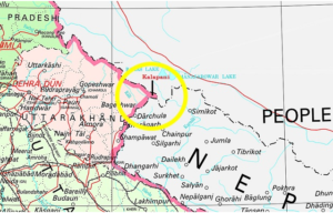
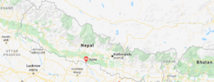
- Currently, India and Nepal have border disputes over Kalapani – Limpiyadhura – Lipulekh trijunction between India-Nepal and China and Susta area (West Champaran district, Bihar).
Kalapani Region
- Kalapani is a valley that is administered by India as a part of the Pithoragarh district of Uttarakhand. It is situated on the Kailash Mansarovar route.
- Kalapani is advantageously located at a height of over 20,000 ft and serves as an observation post for that area.
- The Kali River in the Kalapani region demarcates the border between India and Nepal.
The Treaty of Sugauli signed by the Kingdom of Nepal and British India (after Anglo-Nepalese War) in 1816 located the Kali River as Nepal’s western boundary with India.
- The discrepancy in locating the source of the Kali river led to boundary disputes between India and Nepal, with each country producing maps supporting their own claims.

Susta Region
- The change of course by the Gandak river is the main reason for disputes in the Susta area.
- Susta is located on the bank of the Gandak river.
- It is called Narayani river in Nepal.
- It joins Ganga near Patna, Bihar.

Efforts to Solve Border Dispute
- In the 1980s, the two sides set up the Joint Technical Level Boundary Working Group to delineate the boundary.
- The group demarcated everything except Kalapani and Susta area.
- Officially, Nepal brought the issue of Kalapani before India in 1998. Both sides agreed to demarcate the outstanding areas (including Kalpani) by 2002 at the prime ministerial level talk held in 2000. But that has not happened yet.


