
Atop the Sahara’s highest volcano lies a dazzling mystery that’s reshaping how scientists view one of the driest places on Earth. What looks like snow in this forbidding desert turns out to be a striking clue to the Sahara’s ancient climate — a salt-covered lake bed hidden in plain sight. This unexpected discovery from space opens a window to a wetter, more dynamic Sahara long before the endless dunes took over.
A breathtaking satellite view of Emi Koussi
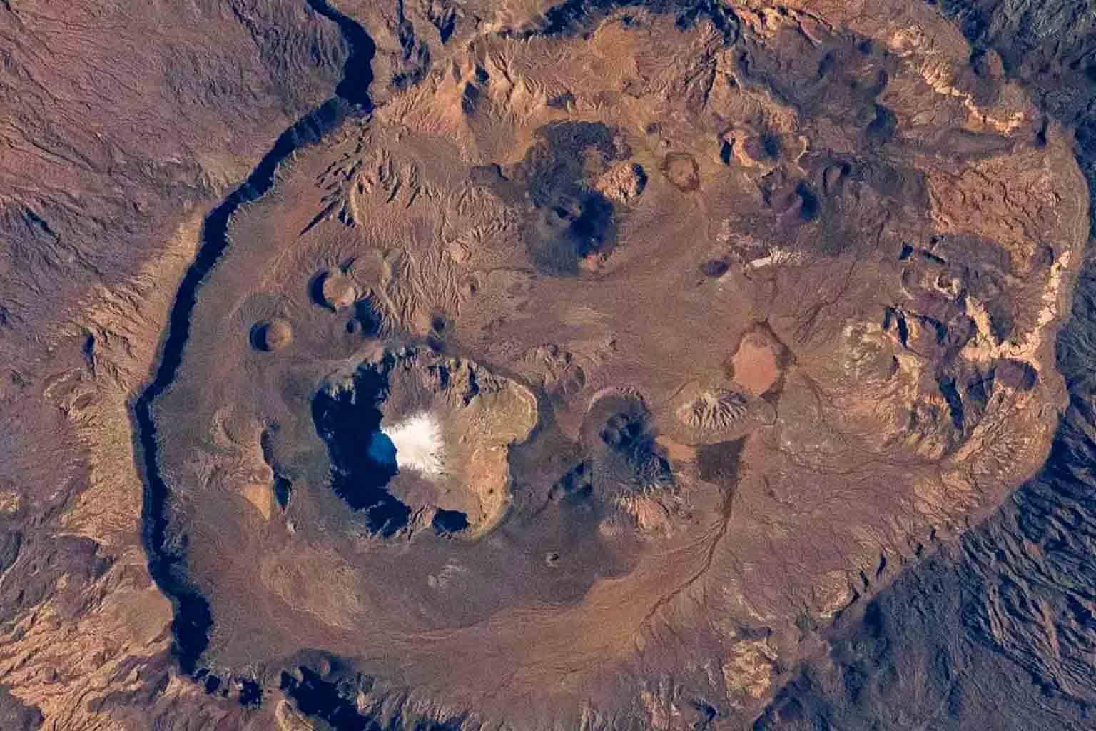
On December 29, 2024, an astronaut aboard the International Space Station (ISS) snapped a breathtaking image that has since captivated geologists and climate experts alike. High above northern Chad’s vast sands, the photo reveals a curious white patch crowning the summit of Emi Koussi, the tallest volcano in the Sahara—standing an impressive 11,204 feet tall.
At first glance, this patch might easily be mistaken for a rare snowfall. Snow in the Sahara is a phenomenon so scarce it captures headlines worldwide. But once experts examined the image more closely, they confirmed this wasn’t snow—it was a residual salt crust coating an ancient lake bed. According to the NASA Earth Observatory, this lake disappeared thousands of years ago, leaving behind these telltale salt deposits as evidence that the Sahara’s climate was once radically different.
Emi Koussi: A volcanic giant with stories etched in stone
Emi Koussi is not just a mountain; it’s a geological giant with a storied past. Its massive volcanic cone spans nearly 44 miles across, and the summit lies along the rim of a vast elliptical caldera. The salt patch sits at the lowest point within this caldera, about 2,444 feet below Emi Koussi’s peak, creating a stark contrast to the surrounding rock. This salt crust is more than just a geological oddity—it’s a symbol of past landscapes transformed by climate shifts.
The volcanic nature of Emi Koussi adds another layer to its significance. Over millennia, volcanic activity built this mountain, but it was water that carved the surrounding terrain. While today’s Sahara is famously arid, the salt bed’s whiteness and the lake it once covered tell a tale of persistence, change, and transformation that challenges our assumptions.
Traces of ancient water flow rewrite Sahara’s climate history
Beyond the salt patch, the astronaut’s photo reveals winding channels etched into Emi Koussi’s slopes. These narrow erosion channels act as natural signatures of water’s past presence. Experts believe these marks were carved over thousands of years during periods when water flowed intermittently across the volcano’s flanks.
Such channels challenge barren desert stereotypes. They suggest that “the Sahara was not always the vast, dry expanse known today but rather a landscape shaped by intermittent rains and flowing water,” explains Dr. Lisa Nguyen in a 2024 geological study published in the Journal of Geophysical Research. This evolving understanding is critical because it sheds light on how climate patterns in North Africa have shifted dramatically over thousands of years.
Shifting perspectives: What the Sahara teaches us about Earth’s past
The ISS image captured by the Expedition 72 crew does more than document one of the Sahara’s volcanic peaks—it tells a larger story about Earth’s climate history. While the Sahara today is synonymous with endless sand dunes and blistering heat, it was once home to vibrant lakes and rivers sustaining diverse ecosystems.
This salt bed atop Emi Koussi is critical evidence of those wetter times. Geologists and climatologists argue that understanding these ancient climates can help forecast future changes, particularly as the planet’s climate faces unprecedented shifts. The interaction of volcanic activity and water erosion seen here is a microcosm of Earth’s broader geological and climatic cycles.
Moreover, the presence of such landscapes in extreme settings like the Sahara encourages a reevaluation of how deserts evolve. The fact that volcanic landscapes intersect with paleolakes invites further research into the relationship between tectonics and climate in arid regions.
Dr. Malik Hassan, a volcanologist at the University of Algiers, notes: “Discoveries like this remind us that Earth’s surface is a palimpsest — a record of overlapping events, each telling us about life conditions in vastly different eras.”
Exploring and preserving the Sahara’s less visible stories is crucial for understanding global climate processes. The capture of such images by astronauts — equipped with modern digital cameras like the Nikon Z9 used for this shot — makes Earth observation an increasingly powerful tool in climate science.
What are your thoughts on what this salt patch reveals about the Sahara’s ancient environment? How does this change your view of deserts? Share your reactions and comments below!