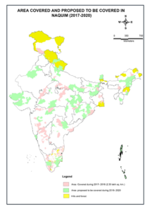
In News: National Aquifer Mapping Programme: Plans developed for 11.8 lakh sq km, the Ministry Jal Shakti replied in Lok Sabha that out of 25 lakh square kilometre of mappable area, plans for 11.8 lakh square km area have been developed.
National Project On Aquifer Management (Naquim) During 2017-20
- NAQUIM is an initiative of the Ministry of Water Resources, Government of India, for mapping and managing the entire aquifer systems in the country.
- The vision of the National Project on Aquifer Management is to identify and map aquifers at the micro level, to quantify the available groundwater resources, and to propose plans appropriate to the scale of demand and aquifer characteristics, and institutional arrangements for participatory management.
- The National Aquifer Mapping and Management Programme was initiated and implemented by the Central Ground Water Board under the scheme of Ground Water Management & Regulation during XII plan (2012-17). The Programme is proposed to be continued in 2017-20, during which a number of scientific activities for data generation, preparation of aquifer maps and management plans will be undertaken through in-house resources of CGWB.
- However, considering the limited manpower and infrastructure facilities available with CGWB, some activities pertaining to data generation, ground water monitoring and ground water modelling shall be completed through outsourcing as well as involvement of State Governments and Academic /Research Institutions.
- The State Governments will be associated with CGWB in various activities related to sharing of existing data and data generation wherever sufficient manpower with required technical capabilities is available.
- The Aquifer Maps and Management Plans will be shared with the State Agencies and stakeholders for implementation.
- Some of the activities will also be outsourced to achieve the targets by hiring the services of consultants/ agencies/ firms having capabilities to perform such works in the ground water sector.
Mapping
- CGWB has identified an area of 25 lakh sq km area for Aquifer Mapping and Management plan. Out of which 6.30 Lakh sq km has been covered till March,2017.
- Further it is envisaged to cover an additional 6.31 Lakh sq km area during 2017-20.
- In addition to above, aquifer mapping and management plan preparation is also proposed to be taken up in the over-exploited and critical assessment units in the aspirational districts.
- In the identified 117 aspirational districts, 77 over-exploited and critical assessment units have been identified to be covered under aquifer mapping and management plan preparation by 2018-19.


