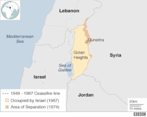
In news- Recently, Israel’s government approved a $317 million plan to double the Jewish settler population in the Golan Heights, 40 years after it annexed the territory captured from Syria.
About Golan Heights-
- Golan Heights, also called Golan Plateau is a hilly area overlooking the upper Jordan River valley on the west.
- The area’s name is from the biblical city of refuge Golan in Bashan.
- Geographically, the Golan is bounded by the Jordan River and the Sea of Galilee on the west, Mount Hermon on the north, the seasonal Wadi Al-Ruqqād (a north-south branch of the Yarmūk River) on the east, and the Yarmūk River on the south.
- It is roughly boat-shaped and has an area of 1,150 square km.

- The area was part of extreme southwestern Syria until 1967.
- Israel occupied it in the 1967 Mideast war and later annexed the territory, promoting settlement and agriculture there as well as creating a thriving local tourism industry.
- The US was the first country to recognise Israel’s sovereignty over the Golan, which the rest of the international community regards as Israeli-occupied.
- A disengagement agreement between Israel and Syria, signed following the Yom Kippur War of October 1973, established a United Nations buffer zone in the Golan Heights, monitored by a UN Disengagement Observer Force (UNDOF).
- The UNDOF mandate was renewed every six months thereafter.


