
Scientists have just confirmed the sudden appearance of a mysterious new island in the northern Caspian Sea. This remarkable discovery, first spotted by satellites in late 2024, marks a rare and dynamic shift in the world’s largest inland body of water. The island’s emergence has captivated researchers and environmentalists alike, painting a vivid picture of how natural forces and climate fluctuations continuously reshape our planet’s geography.
Though still unnamed and unexplored on foot, this new landform promises to add valuable insights into the complex interplay between water level fluctuations and geological processes in the Caspian region.
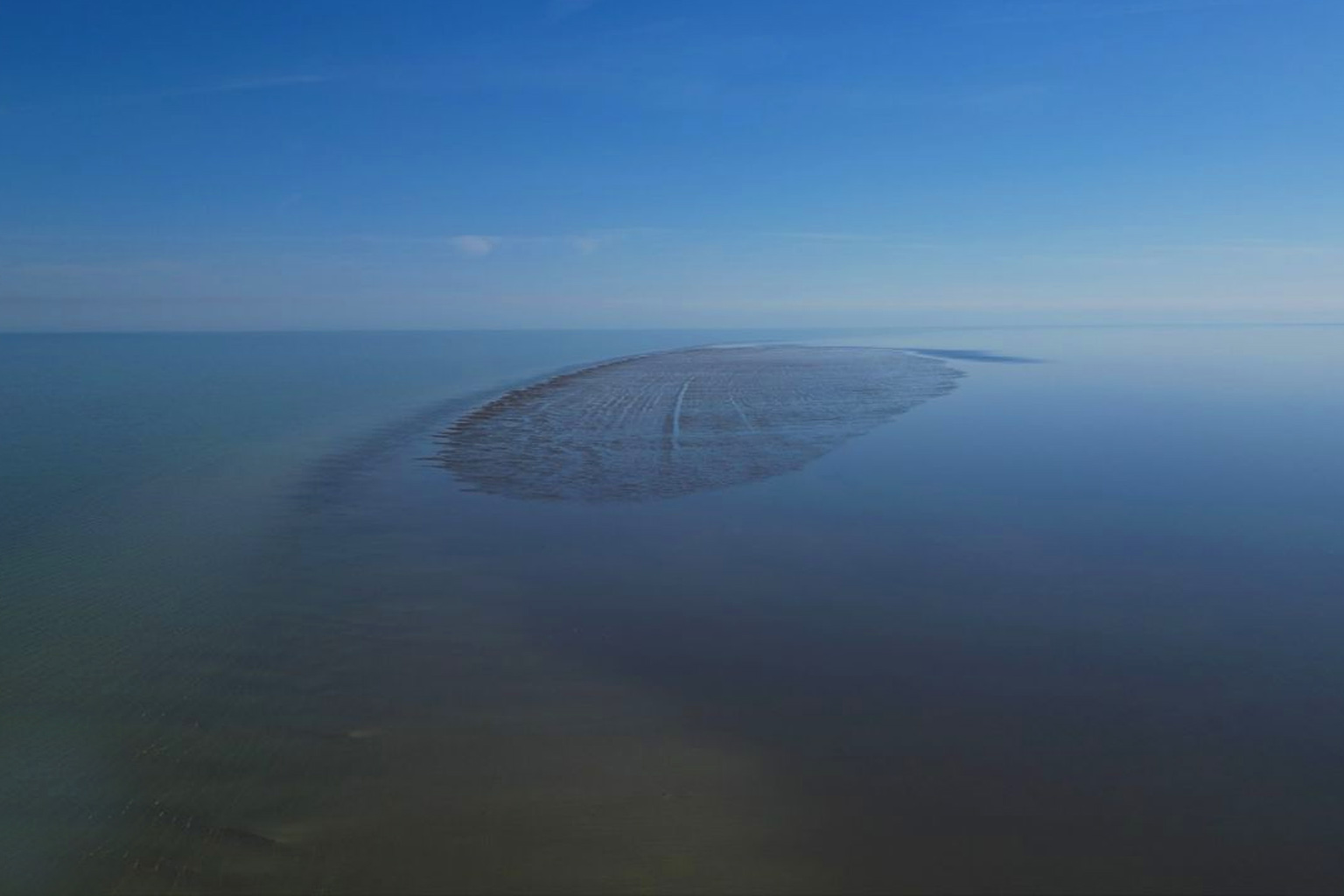
The sudden emergence of a new Caspian Sea island
Located about 19 miles southwest of Maly Zhemchuzhny Island, the newly discovered island is modest in size but rich in significance. Satellite imagery first revealed a sand and sediment mound breaking the water’s surface in November 2024. Subsequent drone photos confirmed its flat, damp surface marked by ridges of sand, illustrating a landscape born from shifting sediments and a declining water level.
Russian scientists from the P. P. Shirshov Institute of Oceanology and the Russian Academy of Sciences have verified the island’s presence but were unable to physically land due to bad weather and dangerously shallow water conditions. Their cautious approach highlights the logistical challenges in studying these transient landforms, yet remote sensing technologies have ensured accurate monitoring from afar.
This is not the first time the Caspian Sea has birthed such islands. Historical records document similar appearances in the 1930s and 1970s, when natural cycles caused the basin’s water to recede and exposed underwater uplifts. These recurring events reveal a fascinating pattern tied to the sea’s unique hydrology.
Water level fluctuations: The driving force behind island formation
The Caspian Sea’s water levels are notoriously volatile, influenced by a mixture of natural climate variations, tectonic activity, and more recently, human-driven climate change. Stepan Podolyako, a senior researcher at the Shirshov Institute, underscores that these islands emerge as part of “cyclical processes of long-term fluctuations” in the sea’s level. When water recedes, portions of the seabed are exposed, revealing new land above the surface.
Experts identify these landforms as “awash islands,” created when seabed uplift rises high enough to break through only during periods of low water. This cycle, while natural, is now intertwined with global warming trends that enhance evaporation, reduce river inflow, and alter precipitation patterns in the Caspian basin.
A 2023 assessment by the United Nations Environment Programme confirms that intensified evaporation rates due to rising global temperatures have accelerated water loss in enclosed seas like the Caspian. This research adds crucial context to understanding the island’s formation as part of broader environmental shifts affecting the region.
The crucial role of satellite and drone technology
The discovery and ongoing monitoring of this island vividly demonstrate the immense value of satellite remote sensing combined with drone reconnaissance. Satellites first detected the surface protrusion, allowing scientists to time observations precisely. Drones have been deployed to capture close-up imagery providing detailed visuals of the island’s morphology even when physical landings are impossible.
This approach is an example of how modern technologies enable researchers to track natural phenomena in inaccessible or environmentally sensitive areas. It also underlines a growing trend in environmental science: using real-time data to document rapid landscape changes driven by climate and geophysical forces.
Environmental and geological forces shaping the Caspian Sea
Multiple layers of environmental factors come into play to create such an island. Since around 2010, the Caspian Sea has undergone another phase of water level decline after partial recovery in previous decades. Researchers link this trend to shifting climate patterns—changes in rainfall, heightened temperatures, and intensified evaporation linked to global warming.
Meanwhile, tectonic movements subtly reshape the seabed, causing uplift zones that can become exposed as drying coastal lands. This convergence of climate-driven hydrology and geology forms a natural laboratory for scientists exploring the impacts of climate change on inland seas.
Stepan Podolyako’s observations reflect a broader understanding shared by experts worldwide: these islands are not anomalies but signs of a living, breathing ecosystem adapting to evolving conditions. Their presence compels us to reexamine how climate change and natural Earth processes interact on local and global scales.
For readers interested in environmental science, the story of this island raises compelling questions. How might this newly visible land influence local ecosystems? Could it serve as a habitat for wildlife, or will it vanish again under rising waters? What lessons can it teach us about climate resilience and the future of fragile aquatic environments?
Share your thoughts, observations, or questions below. Join the conversation and help explore the fascinating dynamics between climate, geography, and life in the Caspian Sea and beyond. Your insights are invaluable in understanding our planet’s ever-changing face.