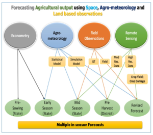
About Forecasting Agricultural output using Space,Agro-meteorology and Land based observations
(FASAL) Programme
- The programme is sponsored by Ministry of Agriculture.
- A team of ISRO/Department of Space, State Remote Sensing Applications Centers, State Agricultural Universities and many other institutions are working on this project.
- Under the operational component of the FASAL programme of the Ministry of Agriculture and Farmers Welfare, MNCFC regularly generates crop forecasts at District/State/National level for 9 major crops of the country, using the procedures developed by Space Applications Centre, ISRO.
- Both optical and microwave Remote sensing data is used for crop acreage estimation, crop condition assessment and production forecasting.
- In the year 2017-18, total 17 forecasts were generated for 9 crops, such as Jute, Kharif Rice, Sugarcane, Cotton, Rapeseed & Mustard, Rabi Sorghum, Wheat, Rabi Pulses and Rabi Rice.

- National/State/District level crop production forecasts were generated using multi-date AWiFS NDVI product/LISS-III/Sentinel 2/ Landsat-8 and multi date Sentinel 1A SAR data for acreage estimation and estimation of crop yield, using multiple approaches,
- semi-physical remote sensing based model
- Remote Sensing index based yield models
- correlation weighted district level Agromet model of IMD iv) Crop simulation model by IMD
- data obtained from crop cutting experiments.
Source: ncfc.gov.in and Indian Express


