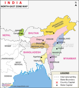
In news-The Union Home Minister is expected to seal the final agreement to end the dispute in six areas of the Assam-Meghalaya boundary ahead of Meghalaya’s 50th Statehood Day celebration on January 21.
About the border dispute-
- Meghalaya was carved out of Assam under the Assam Reorganisation Act, 1971, a law that it challenged, leading to disputes.
- The boundary differences between the two states at 12 points along the 885-km-long inter-state border have existed since the birth of Meghalaya in 1972.
- A major point of contention between Assam and Meghalaya is the district of Langpih in West Garo Hills bordering the Kamrup district of Assam.
- Langpih was part of the Kamrup district during the British colonial period but post-Independence, it became part of the Garo Hills and Meghalaya.
- Assam’s capital was Shillong, Meghalaya’s present capital, before it was shifted to Dispur in 1972.
- Of the 12 areas of dispute between the two states six had been selected for resolution in the first phase.
- Those sites have been identified as at Tarabari, Gizang, Hahim, Baklapara, Khanapara (Pilingkata) and Ratacherra, which fall under Cachar, Kamrup and Kamrup Metropolitan districts of Assam, and corresponding districts of West Khasi Hills, Ri-Bhoi and East Jaintia Hills of Meghalaya.

- Assam and Meghalaya had formed three regional committees each to inspect the disputed areas and record the views of the local residents.
- Six regional border committees, comprising cabinet ministers of both sides for recommending the way forward, submitted their reports recently.
- Historical facts, ethnicity, administrative convenience, mood and sentiments of the people concerned and the contiguity of the land are the five aspects to be considered for resolving this dispute.
- The more complicated disputes at the remaining six sites at Langpih, Borduar, Nongwah, Matamur, Deshdemoreah Block I and Block II and Khanduli will be taken up in the next phase.


