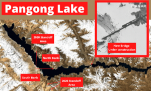
In news- Recently, Satellite images showed an under-construction bridge connecting the north and south banks of the Pangong Tso lake right near India’s claim line that has remained under Chinese control for decades. The under-construction bridge is approximately 315 meters long.
About Pangong Tso lake-
- Formed from Tethys geosyncline, Pangong Tso is a long narrow, deep, endorheic (landlocked) lake situated at a height of more than 14,000 ft in the Ladakh Himalayas.
- In the Ladakhi language, Pangong means extensive concavity and Tso is a lake in Tibetan.
- The lake’s water, while crystal clear, is brackish, making it undrinkable.
- During winter the lake freezes completely, despite being saline water and it is not a part of the Indus river basin area.
- It is a nearly 135-km long, narrow lake — 6 km at its widest point and shaped like a boomerang.
- The Karakoram Mountain range with heights of over 6,000 metres including K2, the world’s second highest peak, ends at the north bank of Pangong Tso.


- Its southern bank too has high broken mountains sloping towards Spangur Lake in the south.
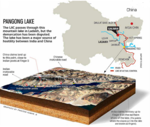
- In the 1990s, when the Indian side laid claims over the area, the Chinese army built a metal-top road contending that it was part of the Aksai Chin.
- One-third of the water body, its 45 km stretch is in Indian control while the rest of the 90 km is under Chinese control.
- The LAC, running north-south, cuts the western part of the lake, aligned east-west.
- An Inner Line Permit is required to visit the lake as it lies on the Sino-Indian Line of Actual Control (LAC).
- The barren mountains on the lake’s northern bank, called the Chang Chenmo, jut forward in major spurs, which the Army calls “fingers”.
- At the lake’s north bank, according to India, the international boundary is close to Khurnak Fort, a 19th-century ruin.
- India says the LAC passes through Finger 8 but China claims it is farther west.


